File:Voseo-extension-real.PNG

From TALOD
Jump to navigation Jump to search

Original file(694 × 922 pixels, file size: 46 KB, MIME type: image/png)

This file is from Wikimedia Commons and may be used by other projects. The description on its file description page there is shown below.

This linguistic map image could be re-created using vector graphics as an SVG file. This has several advantages; see Commons:Media for cleanup for more information. If an SVG form of this image is available, please upload it and afterwards replace this template with {{vector version available|new image name}}.


It is recommended to name the SVG file “Voseo-extension-real.svg”—then the template Vector version available (or Vva) does not need the new image name parameter.

Summary

Description
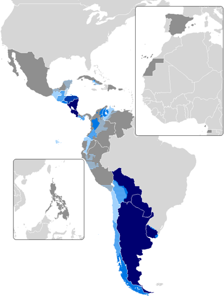
Español: Mapa del voseo en América:
 
Uso generalizado de forma oral y escrita
 
Uso oral generalizado
 
Voseo coexistente con el tuteo
 
País hispanohablante sin voseo
English: Map of countries with voseo phenomena:
 
primary spoken and written form
 
primary spoken, but not in written form
 
'Voseo' coexists with 'tuteo'
 
Spanish-speaking country with voseo non-existent
Galego: Mapa del voseo en hispanoamérica:
 
Uso xeralizado nas formas oral e escrita
 
Uso predominante na forma oral
 
Convive con tuteo
 
País hispanofalante, sen voseo
Date
Source Image:Map-Latin America2.png, Image:BlankMap-World.png, Diccionario Panhispánico de Dudas, Fórmulas de tratamiento en dialectos del español, El Voseo en El Salvador y Latinoamérica, Interpelación y Espacios Comunicativos, Acerca de dónde y cómo se emplea el voseo en Hispanoamérica, El Español en América y Acerca de dónde y cómo se emplea el voseo en Hispanoamérica Variedades beliceñas del español: contacto lingüístico y prácticas plurilingües Language Mixing in Northern and Western Belize: A Comparative Variationist Approach A phonological analysis of the Spanish of Belize
Author Inhakito

Licensing

I, the copyright holder of this work, hereby publish it under the following license:
w:en:Creative Commons
attribution share alike
This file is licensed under the Creative Commons Attribution-Share Alike 3.0 Unported license.
You are free:
  • to share – to copy, distribute and transmit the work
  • to remix – to adapt the work
Under the following conditions:
  • attribution – You must give appropriate credit, provide a link to the license, and indicate if changes were made. You may do so in any reasonable manner, but not in any way that suggests the licensor endorses you or your use.
  • share alike – If you remix, transform, or build upon the material, you must distribute your contributions under the same or compatible license as the original.

Captions

Add a one-line explanation of what this file represents

Items portrayed in this file

depicts

26 July 2012

image/png

File history

Click on a date/time to view the file as it appeared at that time.

Date/TimeThumbnailDimensionsUserComment
current23:34, 17 December 2023Thumbnail for version as of 23:34, 17 December 2023694 × 922 (46 KB)SalvablReverted to version as of 04:16, 4 April 2023 (UTC) Map restored. Philippines had been unilaterally removed from the map

There are no pages that use this file.